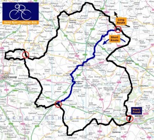
The Route The main Circuit of the Cotswolds route is 104 miles long and true to the memory of David Ryan is hilly and avoids main roads. The route has about 2300 metres of climbing. The opening and closing sections are new for 2012 due to a change of headquarters from Langdale Hall to Witney FC, and we have made two minor changes to avoid passing through the centre of Chipping Norton and Broadway.
Long route Brief route description: Witney FC – Leafield – Cornwell – Great Rollright – Whichford – Cherington (Feeding Station 1) – Shipston-on-Stour – Ilmington – Aston-sub-Edge – Saintbury – Sudeley Hill – Winchcombe (Feeding Station 2) – Gotherington – Cleeve Hill – Corndean Lane – Brockhampton – Compton Abdale – Yanworth – Northleach (Feeding Station 3) – Coln St Aldwyns – Hatherop – Westwell – Shilton – Witney FC.
Short route There is also a shorter route option, 70 miles long. This cuts across the main circuit between the two feeding stations and misses out the biggest climbs at Lark Stoke, Saintbury, Cleeve Hill and Winchcombe. Total climbing is 1200 metres. Brief route description: As long route to Feeding Station 1 – Great Wolford – Evenlode – Stow-on-the-Wold – Northleach then as long route back to Witney.
Route Details – click the links to download PDFs of the Short_route_course_description and the Long_route_course_description
Route Map
Course Profiles – click the link below to download the profile description for both courses
GPS Files – for GPS downloads of the routes click here and download them from the Helen & Douglas House website.
